|
||||||||||||||||||||||||||||||||
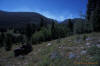
Burn Ridge FireOn Wednesday, August 14, I ventured south from Burn Ridge Trailhead collecting information and pictures for this website. I called the Forest Service that morning before leaving the trailhead to check for trail closures and the status of the Burn Ridge Fire. The fire was 1.5 to 2 miles west of the trail near Burn Ridge according to the Forest Service office that morning, and Swamp Park Trail 1100 was still open to all use. Other forest service workers stopped by the trailhead and gave me conflicting information about the location of the fire, but they still indicated the trail was open. I decided to go as far south on the trail as possible; planning to turn back if I approached the fire. With a hiking season so shortened by fires near the Mount Zirkel Wilderness, I thought an opportunity to hike trails and gather information had to be seized. South of the trailhead, upon entering the valley of the South Fork of the Elk River, the smoke from the fire could be seen ahead.
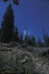
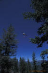
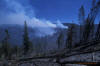
A couple miles south of the Burn Ridge Trailhead, Swamp Park Trail turns south away from the South Fork of the Elk and climbs toward the Burn Creek valley. It soon crosses Burn Creek and follows the creek south along the west side of the valley. Hiking up the valley here, a thick spruce-fir forest is crossed and the view of what lies ahead is obscured by the thick canopy. I didn't realize that the Burn Ridge Fire was actually right in front of me as I hike up the canyon. About a mile from the top of the ridge, smoke was apparent in trees across the valley. I thought the smoke had followed the contours of the ground from the fires west of there, and so continued south along the trail. Upon nearing the crest of Burn Ridge on my way south, I began to smell smoke. The top of the ridge was just ahead, and a good landmark to use as a turnaround point, so I continued a little further up the trail hoping to reach it. Suddenly, a helicopter flew overheard, it hovered then dumped water pretty close to my location. Soon another helicopter hovered and dumped water ahead of me.
A short distance further I reached the top of Burn Ridge and saw that the fire had crossed the trail and was burning on a ridge to the east. There were no hot spots in my area so I took a few pictures before turning around. A firefighter met me on the trail and convinced me it was time to leave the area, speaking softly yet wielding a big axe. I turned and headed back toward my truck.
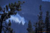
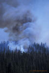
As I headed back down Burn Creek valley, I noticed the trees on the east side of the valley that had smoke in them earlier were on fire. I stopped briefly to take a picture before hurrying down the trail.
The fire had only been burning for three days when these pictures were taken and was only a few hundred acres in size. It initially appeared that the fire would behave like the Big Creek Fire, which had burned near Burn Ridge the previous year. The Big Creek Fire burned and spread slowly in blown down timber from the Routt Divide Blowdown, not entering green patches of forest. Conditions had changed. Colorado was in its worst drought in recorded history in the summer of 2002. Spruce trees killed by a spruce beetle epidemic triggered by the blowdown had another year to dry out. By the next day, Thursday, August 15, a group of backpackers were evacuated by helicopter from near Dome Lake after the fire had moved to block their route back down the South Fork of the Elk River. Firefighters became concerned that this fire would behave much differently than the Big Creek Fire had the year before. When 50 mile per hour winds came out of the west on Friday, August 16, the fire took off in a big way. Firefighters were called off the fire that day for their own safety. The next day the fire crossed the tundra at the Continental Divide, spreading into the Roaring Fork basin north of Red Canyon. The blaze didn't stop growing until reaching the east end of the forest two days later. By Sunday, August 18, the fire had grown to affect about 14,000 acres. It finally ran out of fuel at the east edge of the wilderness after jumping to the south side of Red Canyon, burning both sides of the canyon near its mouth. When wildfires burn, there are times when the fire can move quicker than the information about it, possibly cutting off trails in its path. Always give fires wide berth when traveling through the backcountry since weather and fire conditions can change suddenly and catastrophically. Slow moving fires can flare out of control in a matter of minutes. |
||||||||||||||||||||||||||||||||